Star Walk 2 Plus: Sky Map View
- 4.5
- Rating
- 10.00M
- Installs
- Free
- Price
 Analysis by App-foxy
I found Star Walk 2 Plus: Sky Map View most useful when I wanted to understand what I was seeing rather than simply glance at a star chart. It turns a phone into an educational sky guide, combining a live-looking view of the heavens with explanations that make planets, stars, and constellations easier to place in context. The experience is aimed at curious beginners, families, students, and anyone who enjoys stepping outside for a few minutes to look up.
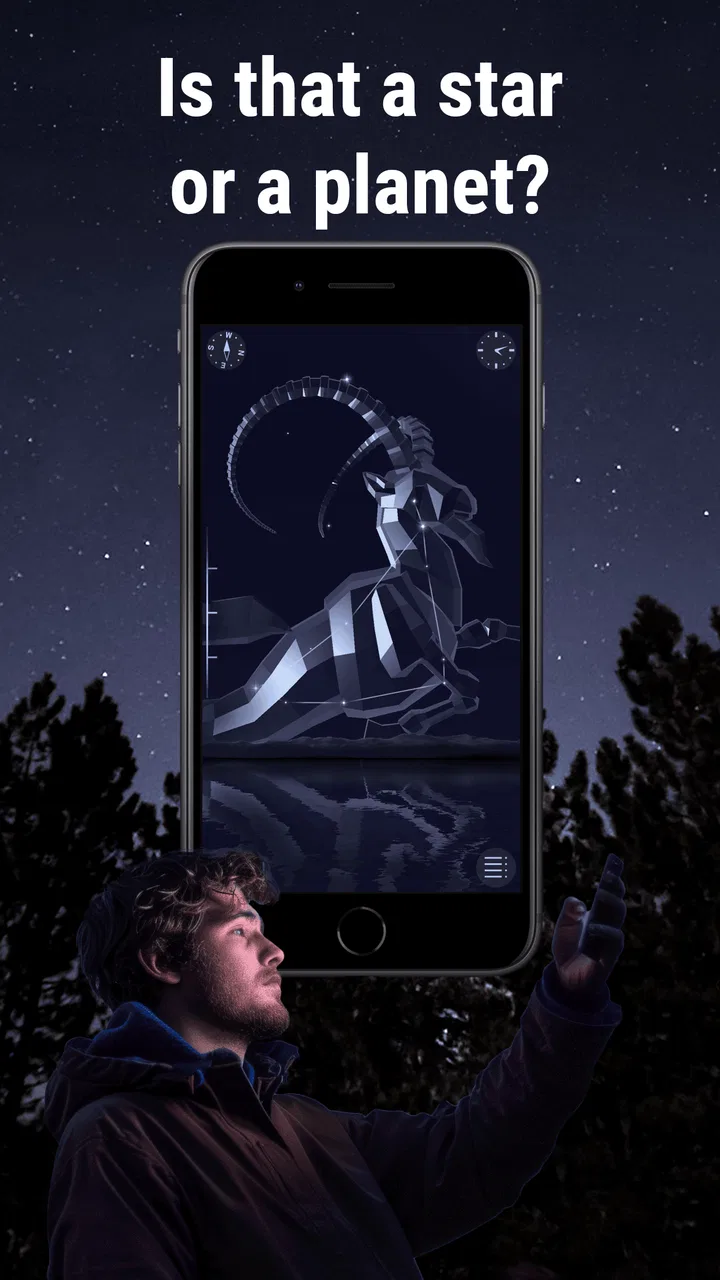
What impressed me first was how quickly the app connects a visual observation with useful background. Instead of wondering whether a bright point is a planet or a star, I can point the phone upward and explore the labels and information around it. That makes it feel more approachable than a traditional astronomy chart, especially for people who do not already know the major constellations.
At the same time, this is still a screen-based tool used outdoors, so its usefulness depends on the situation. Bright daylight, glare, shaky hand movements, a small phone display, or difficulty reading dense information can all change the experience. I spent time looking at it not only as a sky map, but also as an education app that needs to work for different abilities, lighting conditions, and ways of interacting.
You May Also Like

 AccuWeather: Weather Radar
AccuWeather Review: A Quick, Clear Forecast for Everyday Decisions
For everyday plans, the best forecast is the one you can understand quickly. AccuWeather makes rain timing, radar, and local conditions easy to act on, with a few trade-offs.

 Hill Climb Racing
Why Hill Climb Racing Still Turns Crashes Into One More Run
A tiny car, a bumpy hill and one more upgrade: Hill Climb Racing keeps resurfacing because its simple chaos makes every near-miss feel personal.

 AliExpress - Shopping App
AliExpress Makes Global Shopping Feel Personal, but Shoppers Bear the Risk
AliExpress turns a global marketplace into a pocket-sized discovery engine. Its reach is useful, its shopping loop compelling, and its trade-offs easy to miss.

 Lords Mobile: Kingdom Wars
Lords Mobile Is a Kingdom-Building Routine, Not a Quick Match
A case-by-case verdict on the building, battles, device demands, and social commitments that make Lords Mobile rewarding for some players and exhausting for others.

 PDF Scanner app - TapScanner
TapScanner Makes Paperwork Easier to Capture, Check, and Share
TapScanner makes scanning with a phone feel less like a rescue operation and more like a dependable step in getting work done. Its capture tools are useful, though not flawless.

 Block Blast!
 Shows How Much a Puzzle Game Can Leave Out
A quiet grid game shows why puzzle players increasingly value instant clarity, repeatable skill and low-pressure play—and where the genre still needs to catch up.
More From Our News Desk
View All News


How readable and navigable is the sky map?
The main appeal is the direct relationship between the phone’s position and the sky around me. I did not need to begin with a long lesson or manually search through a complicated catalog. Pointing the device gives the experience an immediate quality: I can start from what is physically in front of me and then move toward more detail.
That approach is especially helpful for newcomers. A conventional printed star chart expects me to match orientation, date, time, and location by myself. Here, the app reduces that initial mental workload by presenting the sky as something I can investigate interactively. I still need to pay attention to direction and movement, but the process feels more natural than rotating a paper map in the dark.
The visual presentation is attractive without being purely decorative. Labels and illustrated elements give the sky a recognizable structure, which can make a confusing collection of points feel like a set of objects with names and stories. For a child, that can turn a short walk into a small discovery activity. For an adult beginner, it provides enough guidance to begin building a mental map.
There is a trade-off, though. A rich sky display can become busy when many labels compete for attention. I found that the app works best when I use it in stages: first identify the broad area, then select one object, and only afterward read the supporting information. Trying to absorb every label at once makes the screen less comfortable and reduces the sense of orientation.
One practical habit improved my sessions: I used the app before looking through binoculars or a telescope, not during the observation itself. The phone helped me decide what to look for, while the optical equipment provided a quieter, less screen-dependent view. This workflow avoids constantly switching between a bright display and the dark sky.
Navigation also benefits from short, purposeful sessions. I would choose one constellation, planet, or visible region and explore it rather than endlessly dragging around the map. That makes the educational content easier to remember and is a better fit for users who tire quickly from visual scanning or who prefer a predictable sequence of actions.
Reading support for different visual preferences
For users who see comfortably on a phone, the combination of labels, illustrations, and explanatory material gives several ways to understand the same subject. Someone may recognize a constellation by its outline, another person by its name, and someone else by the accompanying description. That variety is more inclusive than relying on a single visual cue.
However, the app is fundamentally visual. I would not recommend it as the only astronomy resource for a person who cannot comfortably read a phone screen or distinguish small objects against a dark background. Enlarging system text or using device-level display tools may help in some situations, but those adjustments can also change how much information fits on the screen. The result may require more scrolling and less simultaneous context.
People with color-vision differences should also judge the presentation for themselves. Sky maps often use color to separate categories and emphasize objects, and color alone is not an ideal communication method. I found it safer to rely on labels and object descriptions rather than assuming that every visual distinction would be equally clear to everyone.
The app is not a replacement for a tactile or audio-first astronomy resource. Its strength is visual orientation, and that remains its central limitation. If a reader needs content that can be consumed without looking at the display, a dedicated audio guide, narrated lesson, or accessible astronomical reference may be a better primary choice.
Motor, sensory, and cognitive considerations
Holding a phone overhead and slowly turning around sounds simple, but it can be tiring or uncomfortable for people with limited arm strength, tremors, balance difficulties, or restricted range of motion. I found that the experience is easier when I keep my elbows close to my body and move in small arcs instead of sweeping across the entire sky. A chair, bench, or stable surface can make a meaningful difference.
Users who cannot comfortably rotate the device may prefer to explore from a fixed position and use touch-based navigation instead of trying to align the screen with every object outdoors. That is less immersive, but it preserves much of the educational value. It also works better when a group is sharing one phone and passing it around.
Motion can be a sensory issue as well as a motor one. Moving a phone while watching a changing sky view may feel uncomfortable for people who are sensitive to visual motion. I would begin with brief sessions and avoid rapid scanning. Keeping the phone steady, reducing unnecessary movement, and pausing between selections makes the interface calmer.
Night use introduces another concern: the phone itself can become a source of glare. Even when the map is designed for looking at the sky, a bright display can interfere with dark adaptation and disturb companions. I recommend lowering the phone’s brightness as far as remains readable and using the app before the main observing period whenever possible. This is not just a comfort tip; it helps preserve the quality of the actual stargazing.
For people with attention differences, the app can be engaging because it offers many directions to follow, but that same richness can become distracting. I got more from it when I set a small question before opening it: Which bright object is that? Where is a particular constellation? What can I identify from this location? A clear goal turns browsing into a manageable learning task.
Parents and teachers can use that structure with children. Rather than handing over the phone without guidance, I would give the learner one object to find and ask them to explain how they recognized it. This reduces random tapping and encourages observation, memory, and conversation. It also means the child is not required to read every piece of information to benefit from the app.
What the app does well for learning
The strongest educational feature is the bridge between immediate recognition and deeper curiosity. I can begin with a point of light and end up learning about the object’s place in the sky. That progression feels more motivating than starting with an abstract list of astronomical terms.
I also liked using it as a preparation tool. Before an evening outside, I could explore the sky indoors, identify a few targets, and then use the phone less once I went outdoors. This is a useful compromise for anyone who wants guidance but finds prolonged screen use tiring, distracting, or visually uncomfortable.
It is also a good conversation starter for mixed-ability groups. One person can handle the phone, another can describe the direction or shape, and someone else can read the information aloud. The app does not make the activity automatically accessible, but it supports shared exploration when the group adapts the workflow.
The developer, Vito Technology, has positioned this as an education app rather than a specialist observatory instrument. That distinction matters. I see it as an approachable learning companion, not as a substitute for detailed observation planning, professional astronomical software, or equipment designed for precise measurement.
Using it in real situations
A realistic everyday scenario is a family standing outside after dinner with one child asking about a bright object overhead. Instead of guessing, I can open the map, point the phone in the right direction, and let the child follow the identification process. Afterward, we can put the phone away and try to find the same object again without assistance. That second step is important because it turns the app from an answer machine into a memory aid.
In a classroom, I would use it in small groups rather than expecting every student to hold a phone overhead at once. One group could identify a constellation, another could compare nearby objects, and a third could record what they noticed in their own words. This setup gives students with different physical comfort levels more options and reduces the pressure to navigate quickly.
For someone living in a bright urban area, the app can still be valuable as a planning and learning tool, even when only a few stars are visible. It helps explain what should be in the sky, but it cannot make light pollution disappear. Users should not judge the app harshly because their local view is limited; nor should they expect the screen to reproduce the experience of a dark-sky location.
Outdoor conditions create their own access questions. Cold weather can make touch controls harder to use, gloves can reduce precision, and rain or condensation can make a phone screen difficult to read. I would identify targets indoors first, keep the outdoor interaction short, and avoid making the phone the center of the entire activity.
The app is free to start, with optional in-app purchases ranging from $0.99 to $9.99 per item. That makes it relatively easy to try before deciding whether the additional material suits your needs. Still, families should review purchase controls in advance, especially if children will be exploring independently.
It is rated for Everyone, which fits its general educational purpose, but an age rating does not tell me whether every child will find the interface easy to use. Younger users may still need help with orientation, reading, and deciding which information matters. Adult support is particularly useful outdoors, where attention can be divided between the screen, uneven ground, and other people.
Where the experience still creates barriers
The biggest barrier is the assumption that the user can comfortably see, hold, rotate, and interpret a smartphone. That is a lot to ask in a single activity. Touch interaction, visual labels, and physical orientation all matter, so a limitation in any one of those areas can make the app less effective.
Another barrier is environmental. A phone that is easy to read indoors may be hard to see in sunlight, while a display that feels bright enough outside may be unpleasant in darkness. The best experience therefore depends on adjusting the device and choosing the right moment, rather than expecting one setting to work everywhere.
There is also a learning barrier for users who want precision immediately. The app makes astronomy inviting, but beginners may still need a basic explanation of direction, horizon, and apparent movement. Without that foundation, the map can identify objects without fully explaining why they appear where they do. I would pair it with simple offline activities, such as noting the time and direction of an object, to build understanding.
Compared with a printed chart, this app is more interactive and easier to update through a phone-based experience, but paper is quieter, does not produce screen glare, and can be shared without battery concerns. Compared with a general-purpose astronomy reference, this is more immediate and visual, while a reference book may offer a calmer reading experience and more deliberate depth. Compared with specialist sky-planning software, it is friendlier for casual learners but less suited to users who need advanced control or technical preparation.
Those comparisons helped me define the right audience. I would choose this app for discovery, orientation, family learning, and quick identification. I would choose another tool when accessibility depends on audio or tactile content, when the user needs highly detailed planning, or when the goal is simply to relax under the stars without looking at a screen.
My inclusive verdict
Star Walk 2 Plus: Sky Map View is a thoughtful entry point into astronomy because it starts with the user’s immediate question: what am I looking at? Its visual guidance lowers the barrier for beginners, and its educational framing gives the experience more value than a simple label overlay. With a deliberate workflow, it can support children, families, classrooms, and adults who learn best by connecting information to a real place in the sky.
Its inclusive qualities are practical rather than automatic. Users with different abilities may need larger device settings, shorter sessions, a stable seat, shared control of the phone, or another person to read and describe the content. People who are sensitive to motion, glare, or visual density should use it gently and avoid treating the live map as the only way to participate.
The app has earned a 4.6 average from around 562 thousand ratings, and it has passed the ten-million-install mark, which reflects broad interest in this style of sky exploration. It was released on April 28, 2015, and the current version is 2.20.3, with support beginning at iOS or Android system version 7.1. Those details make it a mature, widely used choice rather than an obscure experiment.
I recommend trying the free version in the exact context where you plan to use it: your usual room, balcony, garden, schoolyard, or observing site. Check whether the labels remain comfortable to read, whether you can hold the phone without strain, and whether the display feels acceptable in darkness. If those basics work, the optional purchases can be considered later; if they do not, spending more will not solve the central access problem.
My final view is positive, with one clear qualification: this is best as a flexible visual guide, not a universal astronomy solution. Used in short, purposeful sessions and combined with conversation or offline observation, it makes the night sky more understandable without demanding specialist knowledge. For users who need nonvisual access or who prefer equipment-free, screen-free stargazing, another format will be the better recommendation.
FAQs for Star Walk 2 Plus: Sky Map View
01What is Star Walk 2 Plus and how does it work?
Star Walk 2 Plus is an interactive stargazing app that transforms your smartphone into an astronomical tool. By using your device's GPS, gyroscope, and compass, the app provides a real-time sky map, allowing users to identify stars, constellations, and other celestial bodies. Simply point your device at the sky and discover what's above you.
02Is Star Walk 2 Plus suitable for beginners in astronomy?
Absolutely! Star Walk 2 Plus is designed for both beginners and seasoned stargazers. It offers an intuitive interface with easy-to-understand explanations and tutorials. The app also includes a night mode and augmented reality features, making it accessible and enjoyable for users with varying levels of astronomical knowledge.
03Does Star Walk 2 Plus require an internet connection to function?
Star Walk 2 Plus primarily works offline, which is perfect for stargazing in remote locations. However, certain features like additional data downloads or updates may require an internet connection. The offline functionality ensures that you can access the sky map anytime, anywhere, without worrying about connectivity issues.
04What devices are compatible with Star Walk 2 Plus?
Star Walk 2 Plus is available for both Android and iOS devices. It requires Android version 4.1 or later and iOS version 9.0 or later. The app is optimized to work smoothly across a range of smartphones and tablets, ensuring a seamless stargazing experience regardless of your device.
05Are there any in-app purchases or ads in Star Walk 2 Plus?
Star Walk 2 Plus typically offers a premium user experience without intrusive ads. While the initial purchase provides most features, there might be optional in-app purchases for additional content like extended databases or special guides. These enhance the app's functionality but are not necessary for enjoying the core features.
Pros
- Intuitive interface for easy navigation.
- Rich
- detailed star and constellation info.
- Regular updates with new celestial events.
- AR mode enhances stargazing experience.
- Customizable notifications for events.
Cons
- Limited features in the free version.
- Requires GPS for accurate location data.
- Battery drain with prolonged use.
- Occasional lag on older devices.
- In-app purchases can be costly.

Star Walk 2 Plus: Sky Map View
Gallery